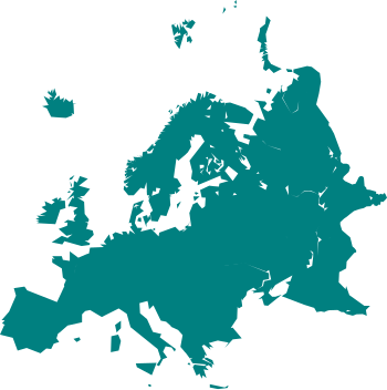
ચિત્ર:Cartography of Europe.svg

Size of this PNG preview of this SVG file: ૩૫૦ × ૩૫૧ પિક્સેલ. અન્ય આવર્તનો: ૨૩૯ × ૨૪૦ પિક્સેલ | ૪૭૯ × ૪૮૦ પિક્સેલ | ૭૬૬ × ૭૬૮ પિક્સેલ | ૧,૦૨૧ × ૧,૦૨૪ પિક્સેલ | ૨,૦૪૨ × ૨,૦૪૮ પિક્સેલ.
મૂળભુત ફાઇલ (SVG ફાઇલ, માત્ર ૩૫૦ × ૩૫૧ પીક્સલ, ફાઇલનું કદ: ૩૧ KB)
ફાઇલનો ઇતિહાસ
તારીખ/સમય ઉપર ક્લિક કરવાથી તે સમયે ફાઇલ કેવી હતી તે જોવા મળશે.
| તારીખ/સમય | લઘુચિત્ર | પરિમાણો | સભ્ય | ટિપ્પણી | |
|---|---|---|---|---|---|
| વર્તમાન | ૧૯:૨૯, ૨૪ માર્ચ ૨૦૨૧ |  | ૩૫૦ × ૩૫૧ (૩૧ KB) | PastelKos | Reverted to version as of 23:02, 23 May 2020 (UTC) so as to match with the other "cartography of ___" maps |
| ૧૮:૨૩, ૨૧ જાન્યુઆરી ૨૦૨૧ |  | ૩૫૦ × ૩૫૧ (૩૧ KB) | Est. 2021 | Reverted to version as of 15:33, 6 January 2010 (UTC) | |
| ૦૪:૩૨, ૨૪ મે ૨૦૨૦ |  | ૩૫૦ × ૩૫૧ (૩૧ KB) | Sittaco | Reverted to version as of 00:20, 12 September 2009 (UTC) | |
| ૨૧:૦૩, ૬ જાન્યુઆરી ૨૦૧૦ |  | ૩૫૦ × ૩૫૧ (૩૧ KB) | Hayden120 | Changed colour to blue; a colour commonly associated with Europe. It also matches the style of 'Portal:Europe' on the English Wikipedia. | |
| ૦૫:૫૦, ૧૨ સપ્ટેમ્બર ૨૦૦૯ |  | ૩૫૦ × ૩૫૧ (૩૧ KB) | TownDown | {{Information |Description={{en|1=x}} |Source=Own work by uploader |Author=TownDown |Date= |Permission= |other_versions= }} Category:svg |
ફાઇલનો વપરાશ
આ ફાઇલને કોઇ પાનાં વાપરતા નથી.
ફાઇલનો વ્યાપક ઉપયોગ
નીચેની બીજી વિકિઓ આ ફાઈલ વાપરે છે:
- ar.wikipedia.org પર વપરાશ
- بوابة:ألمانيا
- بوابة:ألمانيا/بوابات شقيقة
- بوابة:إيطاليا
- بوابة:إيطاليا/بوابات شقيقة
- بوابة:فرنسا
- بوابة:إسبانيا
- بوابة:النمسا
- بوابة:البرتغال
- بوابة:سويسرا
- بوابة:كرواتيا
- بوابة:كرواتيا/شقيقة
- بوابة:بلغاريا
- بوابة:بلغاريا/شقيقة
- بوابة:المجر
- بوابة:المجر/شقيقة
- ويكيبيديا:مشروع ويكي الاتحاد الأوروبي
- بوابة:النمسا/شقيقة
- بوابة:اليونان
- بوابة:اليونان/شقيقة
- بوابة:الدنمارك/بوابات شقيقة
- بوابة:الدنمارك
- بوابة:رومانيا/بوابات شقيقة
- بوابة:رومانيا
- بوابة:ألبانيا/بوابات شقيقة
- بوابة:ألبانيا
- بوابة:مقدونيا الشمالية/بوابات شقيقة
- بوابة:مقدونيا الشمالية
- بوابة:صربيا/بوابات شقيقة
- بوابة:صربيا
- بوابة:البلقان/بوابات شقيقة
- بوابة:البلقان
- بوابة:كوسوفو/بوابات شقيقة
- بوابة:الجبل الأسود/بوابات شقيقة
- بوابة:الجبل الأسود
- بوابة:كوسوفو
- بوابة:البرتغال/بوابات شقيقة
- بوابة:المتوسط
- بوابة:المتوسط/بوابات شقيقة
- بوابة:ألبانيا/شقيقة
- بوابة:إسبانيا/بوابات شقيقة
- بوابة:سويسرا/بوابات أخرى
- بوابة:فرنسا/بوابات شقيقة
- بوابة:دورتموند
- بوابة:دورتموند/بوابات شقيقة
- bn.wikipedia.org પર વપરાશ
- cs.wikipedia.org પર વપરાશ
- de.wikipedia.org પર વપરાશ
- el.wikipedia.org પર વપરાશ
આ ફાઇલના વધુ વૈશ્વિક વપરાશ જુઓ.


